
Search Constraints
You searched for:
Provenance
Indiana state highway system
Remove constraint Provenance: Indiana state highway system
Search Results
-
- Subject:
- Topical Subject: Roads and Geographic Subject: Indiana
- Creator:
- Indiana. Department of Transportation. Graphic Engineering Division
- Publisher:
- Indiana. Department of Transportation
- Date Created:
- 1995
- Identifier:
- VAC3073-M-01225
- Genre:
- Road maps
- Geographic Location:
- Coordinates: W0880500 W0844700 N0414500 N0374600
- Related URL:
- Catalog URL: https://iucat.iu.edu/catalog/18406154
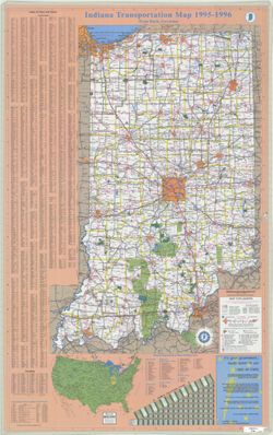
- Abstract:
- Panel title: Indiana 1995-1996 transportation map. Includes indexes, text, color illustrations, distance table, "Map of the United States showing mileag...
- Call Number:
- G1403 .S7 1995-1996
- Caption:
- Imprint: [Indiana] : Indiana Department of Transportation, 1995.
- Physical Description:
- Scale: Approximately 1:633,600 and Dimensions: 94 x 59 cm
- Alternate Identifier:
- Title Control Number: a18406154
- Provenance:
- Indiana state highway system
- Persistent URL:
- https://purl.dlib.indiana.edu/iudl/images/VAC3073/VAC3073-M-01225
-
- Subject:
- Geographic Subject: Indiana and Topical Subject: Roads
- Creator:
- Indiana. State Highway Commission (1961-1981)
- Publisher:
- Indiana. State Highway Commission (1961-1981)
- Date Created:
- 1962
- Identifier:
- VAC3073-M-01224
- Genre:
- Road maps
- Geographic Location:
- Coordinates: W0880500 W0844700 N0414500 N0374600
- Related URL:
- Catalog URL: https://iucat.iu.edu/catalog/18406041
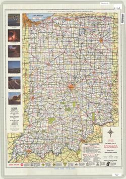
- Abstract:
- Panel title: 1962 Indiana official highway map. Relief shown by spot heights. Includes index, distance table, color illustrations, and text. Index, distance ...
- Call Number:
- G1403 .S7 1962
- Caption:
- Imprint: [Indianapolis] : State Highway Commission, [1962]
- Physical Description:
- Scale: Approximately 1:633,600 and Dimensions: 94 x 59 cm
- Alternate Identifier:
- Title Control Number: a18406041
- Provenance:
- Indiana state highway system
- Persistent URL:
- https://purl.dlib.indiana.edu/iudl/images/VAC3073/VAC3073-M-01224
-
- Subject:
- Geographic Subject: Indianapolis (Ind.), Topical Subject: Central business districts, Topical Subject: Roads, and Geographic Subject: Indiana
- Creator:
- Indiana. Department of Transportation. Graphic Engineering Division
- Publisher:
- Indiana. Department of Transportation
- Date Created:
- 2000
- Identifier:
- VAC3073-M-01227
- Genre:
- Road maps
- Geographic Location:
- Coordinates: W0880500 W0844700 N0414500 N0374600
- Related URL:
- Catalog URL: https://iucat.iu.edu/catalog/18406162
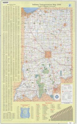
- Abstract:
- Panel title: Indiana 2000 : racing into the--millennium! Includes indexes, indexes to points of interest, distance table, and list of state police phone numb...
- Call Number:
- G1403 .S7 2000
- Caption:
- Imprint: Indianapolis, Ind. : Indiana Department of Transportation, [2000]
- Physical Description:
- Dimensions: 94 x 59 cm and Scale: Approximately 1:650,000
- Alternate Identifier:
- Title Control Number: a18406162
- Provenance:
- Indiana state highway system
- Persistent URL:
- https://purl.dlib.indiana.edu/iudl/images/VAC3073/VAC3073-M-01227
-
- Subject:
- Topical Subject: Roads and Geographic Subject: Indiana
- Creator:
- Indiana. State Highway Department
- Publisher:
- Indianapolis, Ind.: The Dept.,
- Date Created:
- 1960
- Identifier:
- VAC3073-M-01223
- Genre:
- Road maps
- Geographic Location:
- Coordinates: W0880500 W0844700 N0414500 N0374600
- Related URL:
- Catalog URL: https://iucat.iu.edu/catalog/18406084
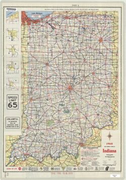
- Abstract:
- Panel title: 1960 Indiana official highway map. Includes 5 local route maps. Includes index, U.S. distance map, mileage chart, color illustrations, index and...
- Call Number:
- G4091.P2 1960 .I53
- Caption:
- Imprint: [Indianapolis] : State Highway Department of Indiana, [1960]
- Physical Description:
- Scale: Approximately 1:633,600 and Dimensions: 94 x 59 cm
- Alternate Identifier:
- Title Control Number: a18406084
- Provenance:
- Indiana state highway system
- Persistent URL:
- https://purl.dlib.indiana.edu/iudl/images/VAC3073/VAC3073-M-01223
-
- Subject:
- Geographic Subject: Indiana and Topical Subject: Roads
- Creator:
- Indiana. State Highway Commission (1919-1953)
- Publisher:
- Indiana. State Highway Commission (1919-1953)
- Date Created:
- 1952
- Identifier:
- VAC3073-M-01222
- Genre:
- Road maps
- Geographic Location:
- Coordinates: W0880500 W0844700 N0414500 N0374600
- Related URL:
- Catalog URL: https://iucat.iu.edu/catalog/18406078
- Abstract:
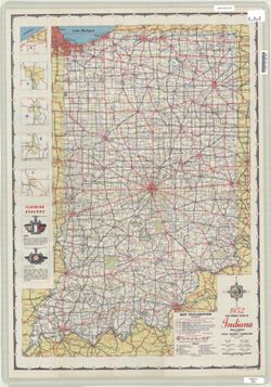
- Panel title: 1952 Indiana official highway map. Relief shown by spot heights. Includes text, color illustrations, and 5 local route maps. Index, distance cha...
- Call Number:
- G1403 .S7 1952
- Caption:
- Imprint: [Indianapolis] : State Highway Commission, [1952]
- Physical Description:
- Dimensions: 94 x 59 cm and Scale: Approximately 1:633,600
- Alternate Identifier:
- Title Control Number: a18406078
- Provenance:
- Indiana state highway system
- Persistent URL:
- https://purl.dlib.indiana.edu/iudl/images/VAC3073/VAC3073-M-01222
-
- Subject:
- Topical Subject: Roads and Geographic Subject: Indiana
- Creator:
- Indiana. State Highway Department
- Publisher:
- Indiana. State Highway Department
- Date Created:
- 1959
- Identifier:
- VAC3073-M-01221
- Genre:
- Road maps
- Geographic Location:
- Coordinates: W0880500 W0844700 N0414500 N0374600
- Related URL:
- Catalog URL: https://iucat.iu.edu/catalog/18406081
- Abstract:
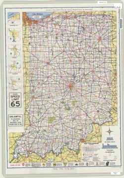
- Panel title: 1959 Indiana official highway map. Relief shown by spot heights. Includes illustrations and 5 local route maps. Index, distance chart, distance ...
- Call Number:
- G1403 .S7 1959
- Caption:
- Imprint: [Indianapolis] : State Highway Department, [1959]
- Physical Description:
- Scale: Approximately 1:633,600 and Dimensions: 94 x 59 cm
- Alternate Identifier:
- Title Control Number: a18406081
- Provenance:
- Indiana state highway system
- Persistent URL:
- https://purl.dlib.indiana.edu/iudl/images/VAC3073/VAC3073-M-01221
-
- Subject:
- Geographic Subject: Indiana and Topical Subject: Roads
- Creator:
- Indiana. State Highway Department
- Publisher:
- Indiana. State Highway Department
- Date Created:
- 1956
- Identifier:
- VAC3073-M-01220
- Genre:
- Road maps
- Geographic Location:
- Coordinates: W0880500 W0844700 N0414500 N0374600
- Related URL:
- Catalog URL: https://iucat.iu.edu/catalog/18406080
- Abstract:
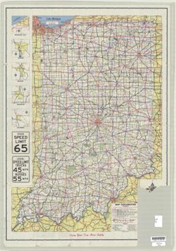
- Panel title: 1956 Indiana official highway map. Relief shown by spot heights. Includes 5 local route maps and illustrations. Index, distance chart, distance ...
- Call Number:
- G1403 .S7 1956
- Caption:
- Imprint: [Indianapolis] : State Highway Department, [1956]
- Physical Description:
- Scale: Approximately 1:633,600 and Dimensions: 94 x 59 cm
- Alternate Identifier:
- Title Control Number: a18406080
- Provenance:
- Indiana state highway system
- Persistent URL:
- https://purl.dlib.indiana.edu/iudl/images/VAC3073/VAC3073-M-01220
-
- Subject:
- Topical Subject: Roads and Geographic Subject: Indiana
- Creator:
- Indiana. Department of Transportation. Division of Program Development
- Publisher:
- Indiana. Department of Transportation
- Date Created:
- 1993
- Identifier:
- VAC3073-M-01217
- Genre:
- Road maps
- Geographic Location:
- Coordinates: W0880500 W0844700 N0414500 N0374600
- Related URL:
- Catalog URL: https://iucat.iu.edu/catalog/18406105
- Abstract:
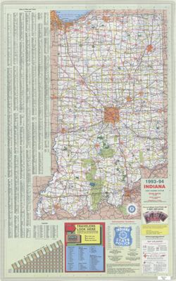
- Panel title: Indiana state highway map, 1993-1994. Includes indexes to cities and towns and counties, mileage chart, state police telephone directory, travel...
- Call Number:
- G1403 .S7 1993-1994
- Caption:
- Imprint: [Indianapolis]. : Indiana Department of Transportation, [1993]
- Physical Description:
- Scale: Approximately 1:633,600 and Dimensions: 94 x 59 cm
- Alternate Identifier:
- Title Control Number: a18406105
- Provenance:
- Indiana state highway system
- Persistent URL:
- https://purl.dlib.indiana.edu/iudl/images/VAC3073/VAC3073-M-01217
-
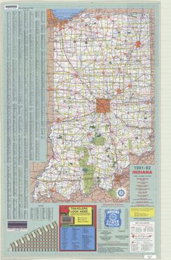
- Subject:
- Topical Subject: Roads and Geographic Subject: Indiana
- Creator:
- Indiana. Department of Transportation. Division of Engineering Services
- Publisher:
- Indiana. Department of Transportation
- Date Created:
- 1991
- Identifier:
- VAC3073-M-01216
- Genre:
- Road maps
- Geographic Location:
- Coordinates: W0880500 W0844700 N0414500 N0374600
- Related URL:
- Catalog URL: https://iucat.iu.edu/catalog/18406103
- Abstract:
- Panel title: Indiana, 1991-1992. Includes indexes, list of points of interest, mileage chart, and directories. Text, illustrations (some color), and 16 local...
- Call Number:
- G1403 .S7 1991-1992
- Caption:
- Imprint: [Indianapolis] : [Indiana Department of Transportation], [1991]
- Physical Description:
- Scale: Approximately 1:633,600 and Dimensions: 94 x 59 cm
- Alternate Identifier:
- Title Control Number: a18406103
- Provenance:
- Indiana state highway system
- Persistent URL:
- https://purl.dlib.indiana.edu/iudl/images/VAC3073/VAC3073-M-01216
-
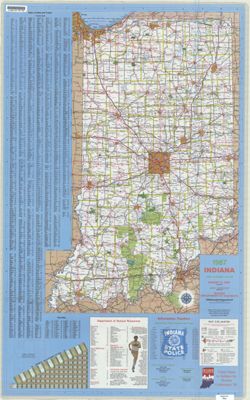
- Subject:
- Geographic Subject: Indiana, Topical Subject: Special Olympics, Inc., and Topical Subject: Roads
- Creator:
- Indiana. Department of Highways. Division of Program Development
- Publisher:
- Indiana. Department of Highways. Division of Program Development
- Date Created:
- 1987
- Identifier:
- VAC3073-M-01212
- Genre:
- Road maps
- Geographic Location:
- Coordinates: W0880500 W0844700 N0414500 N0374600
- Related URL:
- Catalog URL: https://iucat.iu.edu/catalog/18406098
- Abstract:
- Title on verso: Indiana 1987 : America's amateur sports center. Includes indexes, indexed table of recreation areas, information numbers, and distance ch...
- Call Number:
- G1403 .S7 1987
- Caption:
- Imprint: Indianapolis, IN : Department of Highways, Division of Program Development, [1987]
- Physical Description:
- Scale: Approximately 1:633,600 and Dimensions: 94 x 59 cm
- Alternate Identifier:
- Title Control Number: a18406098
- Provenance:
- Indiana state highway system
- Persistent URL:
- https://purl.dlib.indiana.edu/iudl/images/VAC3073/VAC3073-M-01212

- « Previous
- Next »
- 1
- 2
- 3
- 4