
Search Constraints
You searched for:
Provenance
Indiana state highway system
Remove constraint Provenance: Indiana state highway system
Search Results
-
- Subject:
- Geographic Subject: Indiana and Topical Subject: Roads
- Creator:
- Indiana. Department of Highways. Division of Program Development
- Publisher:
- Indiana. Department of Highways
- Date Created:
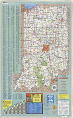
- 1989
- Identifier:
- VAC3073-M-01214
- Genre:
- Road maps
- Geographic Location:
- Coordinates: W0880500 W0844700 N0414500 N0374600
- Related URL:
- Catalog URL: https://iucat.iu.edu/catalog/18406101
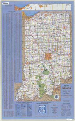
- Abstract:
- Panel title: Indiana, 1989. Relief shown by spot heights. Includes index, distance chart, directory of state police districts, and indexed list of state recr...
- Call Number:
- G1403 .S7 1989
- Caption:
- Imprint: [Indianapolis] : Indiana Department of Highways, [1989]
- Physical Description:
- Scale: Approximately 1:633,600 and Dimensions: 94 x 59 cm
- Alternate Identifier:
- Title Control Number: a18406101
- Provenance:
- Indiana state highway system
- Persistent URL:
- https://purl.dlib.indiana.edu/iudl/images/VAC3073/VAC3073-M-01214
-
- Subject:
- Geographic Subject: Indiana and Topical Subject: Roads
- Creator:
- Indiana. Department of Highways. Division of Program Development
- Publisher:
- Indiana. Department of Highways.
- Date Created:
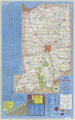
- 1988
- Identifier:
- VAC3073-M-01213
- Genre:
- Road maps
- Geographic Location:
- Coordinates: W0880500 W0844700 N0414500 N0374600
- Related URL:
- Catalog URL: https://iucat.iu.edu/catalog/18406100
- Abstract:
- Panel title: Indiana, 1988. Relief shown by spot heights. Includes index, distance chart, directory of state police locations, indexed list of state recreati...
- Call Number:
- G1403 .S7 1988
- Caption:
- Imprint: [Indianapolis] : Indiana Department of Highways, [1988]
- Physical Description:
- Scale: Approximately 1:633,600 and Dimensions: 94 x 59 cm
- Alternate Identifier:
- Title Control Number: a18406100
- Provenance:
- Indiana state highway system
- Persistent URL:
- https://purl.dlib.indiana.edu/iudl/images/VAC3073/VAC3073-M-01213
-
- Subject:
- Topical Subject: Roads and Geographic Subject: Indiana
- Creator:
- Indiana. Department of Highways. Division of Program Development
- Publisher:
- Indiana. Department of Highways
- Date Created:
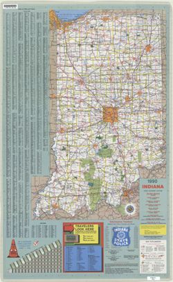
- 1990
- Identifier:
- VAC3073-M-01215
- Genre:
- Road maps
- Geographic Location:
- Coordinates: W0880500 W0844700 N0414500 N0374600
- Related URL:
- Catalog URL: https://iucat.iu.edu/catalog/18406102
- Abstract:
- Panel title: Indiana, 1990 : crossroads. Relief shown by spot heights. Includes index, distance chart, directory of state police districts, list of scenic by...
- Call Number:
- G1403 .S7 1990
- Caption:
- Imprint: [Indianapolis] : Indiana Department of Highways, [1990]
- Physical Description:
- Scale: Approximately 1:633,600 and Dimensions: 94 x 59 cm
- Alternate Identifier:
- Title Control Number: a18406102
- Provenance:
- Indiana state highway system
- Persistent URL:
- https://purl.dlib.indiana.edu/iudl/images/VAC3073/VAC3073-M-01215
-
- Subject:
- Topical Subject: Roads and Geographic Subject: Indiana
- Creator:
- Indiana. Department of Highways. Division of Planning
- Publisher:
- Indiana. Department of Highways
- Date Created:
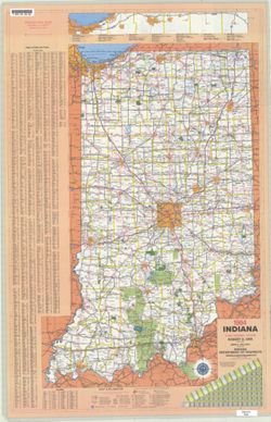
- 1984
- Identifier:
- VAC3073-M-01210
- Genre:
- Road maps
- Geographic Location:
- Coordinates: W0880500 W0844700 N0414500 N0374600
- Related URL:
- Catalog URL: https://iucat.iu.edu/catalog/18406095
- Abstract:
- Panel title: Indiana, 1984. Relief shown by spot heights. Includes index, distance chart, and indexed inset "Indiana toll road." Text, Department o...
- Call Number:
- G1403 .S7 1984
- Caption:
- Imprint: [Indianapolis] : Indiana Department of Highways, [1984]
- Physical Description:
- Scale: Approximately 1:633,600 and Dimensions: 94 x 59 cm
- Alternate Identifier:
- Title Control Number: a18406095
- Provenance:
- Indiana state highway system
- Persistent URL:
- https://purl.dlib.indiana.edu/iudl/images/VAC3073/VAC3073-M-01210
-
- Subject:
- Geographic Subject: Indiana and Topical Subject: Roads
- Creator:
- Indiana. Department of Highways. Division of Planning
- Publisher:
- Indiana. Department of Highways
- Date Created:
- 1986
- Identifier:
- VAC3073-M-01211
- Genre:
- Road maps
- Geographic Location:
- Coordinates: W0880500 W0844700 N0414500 N0374600
- Related URL:
- Catalog URL: https://iucat.iu.edu/catalog/18406097
- Abstract:
- Panel title: Indiana, 1986. Includes Indiana Toll Road map and indexes to cities and towns, counties, and Department of Natural Resources locations. Includes...
- Call Number:
- G1403 .S7 1986
- Caption:
- Imprint: Indianapolis : Indiana Department of Highways, 1986.
- Physical Description:
- Dimensions: 94 x 59 cm and Scale: Approximately 1:633,600
- Alternate Identifier:
- Title Control Number: a18406097
- Provenance:
- Indiana state highway system
- Persistent URL:
- https://purl.dlib.indiana.edu/iudl/images/VAC3073/VAC3073-M-01211
-
- Subject:
- Geographic Subject: Indiana and Topical Subject: Roads
- Creator:
- Indiana. Department of Highways. Division of Planning
- Publisher:
- Indiana. Department of Highways. Division of Planning
- Date Created:
- 1982
- Identifier:
- VAC3073-M-01209
- Genre:
- Road maps
- Geographic Location:
- Coordinates: W0880500 W0844700 N0414500 N0374600
- Related URL:
- Catalog URL: https://iucat.iu.edu/catalog/18406093
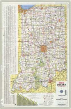
- Abstract:
- Panel title: Indiana 1982-83 official highway map. Relief shown by spot heights. Includes index, distance chart, and text. Text, Department of Natural Resour...
- Call Number:
- G1403 .S7 1982-1983
- Caption:
- Imprint: [Indianapolis] : Indiana Department of Highways, [1982]
- Physical Description:
- Scale: Approximately 1:633,600 and Dimensions: 94 x 59 cm
- Alternate Identifier:
- Title Control Number: a18406093
- Provenance:
- Indiana state highway system
- Persistent URL:
- https://purl.dlib.indiana.edu/iudl/images/VAC3073/VAC3073-M-01209
-
- Subject:
- Topical Subject: Roads and Geographic Subject: Indiana
- Creator:
- Indiana. State Highway Commission (1961-1981)
- Publisher:
- Indiana. State Highway Commission (1961-1981)
- Date Created:
- 1981
- Identifier:
- VAC3073-M-01208
- Genre:
- Road maps
- Geographic Location:
- Coordinates: W0880500 W0844700 N0414500 N0374600
- Related URL:
- Catalog URL: https://iucat.iu.edu/catalog/18406091
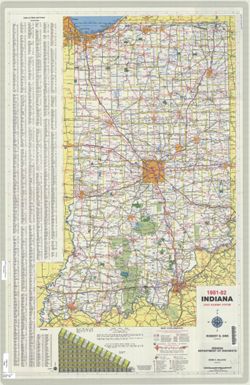
- Abstract:
- Panel title: Indiana 1981-82 official highway map. Relief shown by spot heights. Includes index, text and distance chart. Text, Department of Natural Resourc...
- Call Number:
- G1403 .S7 1981-1982
- Caption:
- Imprint: [Indianapolis] : Indiana Department of Highways, [1981]
- Physical Description:
- Scale: Approximately 1:633,600 and Dimensions: 94 x 59 cm
- Alternate Identifier:
- Title Control Number: a18406091
- Provenance:
- Indiana state highway system
- Persistent URL:
- https://purl.dlib.indiana.edu/iudl/images/VAC3073/VAC3073-M-01208
-
- Subject:
- Geographic Subject: Indiana and Topical Subject: Roads
- Creator:
- Indiana. State Highway Commission (1961-1981). Division of Planning
- Publisher:
- Indiana. State Highway Commission (1961-1981). Division of Planning
- Date Created:
- 1980
- Identifier:
- VAC3073-M-01207
- Genre:
- Road maps
- Geographic Location:
- Coordinates: W0880500 W0844700 N0414500 N0374600
- Related URL:
- Catalog URL: https://iucat.iu.edu/catalog/18406003
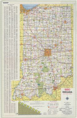
- Abstract:
- Panel title: Indiana 1980 official highway map. Relief shown by spot heights. Includes index, distance chart and text. Text, index and directory to Dept. of ...
- Call Number:
- G1403 .S7 1980
- Caption:
- Imprint: Indianapolis : Indiana State Highway Commission, [1980]
- Physical Description:
- Dimensions: 94 x 59 cm and Scale: Approximately 1:633,600
- Alternate Identifier:
- Title Control Number: a18406003
- Provenance:
- Indiana state highway system
- Persistent URL:
- https://purl.dlib.indiana.edu/iudl/images/VAC3073/VAC3073-M-01207
-
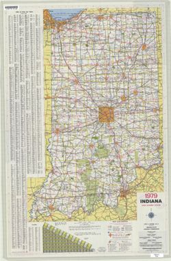
- Subject:
- Geographic Subject: Indiana and Topical Subject: Roads
- Creator:
- Indiana. State Highway Commission (1961-1981). Division of Planning
- Publisher:
- Indiana. State Highway Commission (1961-1981). Division of Planning
- Date Created:
- 1979
- Identifier:
- VAC3073-M-01206
- Genre:
- Road maps
- Geographic Location:
- Coordinates: W0880500 W0844700 N0414500 N0374600
- Related URL:
- Catalog URL: https://iucat.iu.edu/catalog/18406001
- Abstract:
- Panel title: Indiana 1979 official highway map. Relief shown by spot heights. Includes index, distance chart, and text. Text, indexed chart of state recreati...
- Call Number:
- G1403 .S7 1979
- Caption:
- Imprint: Indianapolis : Indiana State Highway Commission, [1979]
- Physical Description:
- Scale: Approximately 1:633,600 and Dimensions: 94 x 59 cm
- Alternate Identifier:
- Title Control Number: a18406001
- Provenance:
- Indiana state highway system
- Persistent URL:
- https://purl.dlib.indiana.edu/iudl/images/VAC3073/VAC3073-M-01206
-
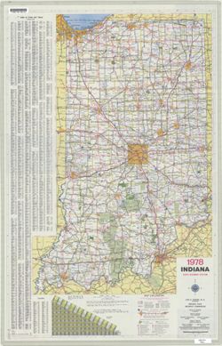
- Subject:
- Topical Subject: Roads and Geographic Subject: Indiana
- Creator:
- Indiana. State Highway Commission (1961-1981). Division of Planning
- Publisher:
- Indiana. State Highway Commission (1961-1981). Division of Planning
- Date Created:
- 1978
- Identifier:
- VAC3073-M-01205
- Genre:
- Road maps
- Geographic Location:
- Coordinates: W0880500 W0844700 N0414500 N0374600
- Related URL:
- Catalog URL: https://iucat.iu.edu/catalog/18405999
- Abstract:
- Panel title: Indiana 1978 official highway map. Includes index and mileage chart. Insets on verso: Falls City area -- Columbus -- Bloomington -- Evansville -...
- Call Number:
- G1403 .S7 1978
- Caption:
- Imprint: [Indianapolis] : Indiana State Highway Commission, 1978.
- Physical Description:
- Dimensions: 94 x 59 cm and Scale: Approximately 1:633,600
- Alternate Identifier:
- Title Control Number: a18405999
- Provenance:
- Indiana state highway system
- Persistent URL:
- https://purl.dlib.indiana.edu/iudl/images/VAC3073/VAC3073-M-01205

- « Previous
- Next »
- 1
- 2
- 3
- 4