
Image
Soil map, Indiana, Marion County sheet Public Deposited
- Genre
- Thematic maps
- Location
- Coordinates: W0862000 W0855700 N0395600 N0393800
- Related URL
- Abstract
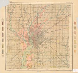
- Shows soil types classification by colors and symbols. "Field Operations, Bureau of Soils, 1907." "Julius Bien & Co. Lith. N.Y."
- Call Number
- G4093.M3J3 1907 .G45
- Caption
- Imprint: [Washington, D.C.?] : The Bureau, [1907?]
- Filename
- VAC3073-M-00045
- Subject
- Topical Subject: Soils
- Geographic Subject: Marion County (Ind.)
- Title
- Soil map, Indiana, Marion County sheet
- Producer
- Geib, W. J. (Warren Jacob), 1880-
- Physical Description
- Dimensions: 51 x 50 cm
- Scale: 1:63,360
- Item Identifiers
- Title Control Number: CAY7156BB
- Persistent Identifier
- Holding Location
- Bloomington - Herman B Wells Library
1320 E 10th St.
Bloomington, IN 47405
Contact at libref@iu.edu, (812) 855-0100
- Bloomington - Herman B Wells Library
- Campus
- IU Bloomington
- Date Created
- 1907
- Publisher
- United States. Bureau of Soils
Relationships
Relationships
- In Collection:
Items
Show Item Images
| Thumbnail | Title | Date Uploaded | Visibility | Actions |
|---|---|---|---|---|
|
VAC3073-00161.jp2 | 2023-09-21 | Public |
|