
Image
Counties and townships Public Deposited
- Genre
- Thematic maps
- Location
- Coordinates: W0880700 W0844500 N0414500 N0374600
- Related URL
- Abstract
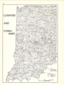
- Shows locations of Indiana counties and townships. Detached from: An atlas of Indiana / by Robert C. Kingsbury , with contributions from John M. Hollingsworth and others. Bloomington, Indiana : Department of Geography, Indiana University, [1970]. Page 10.
- Call Number
- G4091.F7 1970 .K56
- Caption
- Imprint: Bloomington, Indiana : Department of Geography, Indiana University, [1970]
- Filename
- VAC3073-M-00412
- Subject
- Geographic Subject: Indiana
- Topical Subject: Administrative and political divisions
- Topical Subject: Counties
- Title
- Counties and townships
- Producer
- Kingsbury, Robert C.
- Hollingsworth, John M.
- Physical Description
- Scale: Approximately 1:1,800,000
- Dimensions: 26 x 18 cm, on sheet 28 x 21 cm
- Item Identifiers
- Title Control Number: a15942420
- Alternate ID: 317383IP
- Persistent Identifier
- Campus
- IU Bloomington
- Date Created
- 1970
- Provenance
- An atlas of Indiana / by Robert C. Kingsbury [1970].
- Publisher
- Indiana University. Department of Geography
Relationships
Relationships
- In Collection:
Items
Show Item Images
| Thumbnail | Title | Date Uploaded | Visibility | Actions |
|---|---|---|---|---|
|
VAC3073-M-00412.jp2 | 2023-09-25 | Public |
|