
Image
Map of Monroe County Indiana Public Deposited
- Genre
- Maps
- Related URL
- Abstract
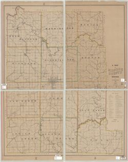
- Sheets included NE sheet, NW sheet, SE sheet, SW sheet Glossy photograph on Kodak paper. Reproduction of a printed map. Reproduced by John Robbins, a former graduate student, in the Indiana University, Bloomington, Geography Dept. darkroom in about 1980. Shows townships, sections, drainage, roads, schools, post offices, quarries, and stone mills. Includes "Stone directory" listing quarries and the companies that operate them. 1 map on 4 sheets, photocopy.
- Call Number
- G4093.M7 1895 .S543 NE sheet
- Filename
- VAC3073-M-01197
- Subject
- Geographic Subject: Monroe County (Ind.)
- Title
- Map of Monroe County Indiana
- Producer
- Siebenthal, C. E. (Claude Ellsworth), 1869-1930
- Physical Description
- Dimensions: 81 x 64 cm, on sheets 51 x 41 cm
- Scale: Approximately 1:52,000
- Persistent Identifier
- Holding Location
- Bloomington - Herman B Wells Library
1320 E 10th St.
Bloomington, IN 47405
Contact at libref@iu.edu, (812) 855-0100
- Bloomington - Herman B Wells Library
- Campus
- IU Bloomington
- Date Created
- 1895
- Publisher
- Julius Bien & Co.
Relationships
Relationships
- In Collection:
Items
Show Item Images
| Thumbnail | Title | Date Uploaded | Visibility | Actions |
|---|---|---|---|---|
|
VAC3073-M-01197.jp2 | 2023-09-27 | Public |
|