
Image
Soil map, Washington County, Indiana Public Deposited
- Genre
- Thematic maps
- Location
- Coordinates: W0861900 W0855100 N0384700 N0382500
- Related URL
- Abstract
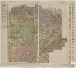
- Shows soil types classification by colors and symbols. "Field Operations, Bureau of Chemistry and Soils." "Litho Eastern Offset Inc., Balto."
- Call Number
- G4093 .W5J3 1932 .M55
- Caption
- Imprint: [Washington, D.C.?] : The Bureau of Soils, [1932]
- Filename
- VAC3073-M-00942
- Subject
- Topical Subject: Soils
- Geographic Subject: Washington County (Ind.)
- Topical Subject: Classification
- Title
- Soil map, Washington County, Indiana
- Producer
- Miller, J. T. (John T.), 1906-
- Physical Description
- Scale: 1:63,360
- Dimensions: 63 x 64 cm
- Item Identifiers
- Title Control Number: CAZ1439BB
- Persistent Identifier
- Holding Location
- Bloomington - Herman B Wells Library
1320 E 10th St.
Bloomington, IN 47405
Contact at libref@iu.edu, (812) 855-0100
- Bloomington - Herman B Wells Library
- Campus
- IU Bloomington
- Date Created
- 1932
- Publisher
- United States. Bureau of Soils
Relationships
Relationships
- In Collection:
Items
Show Item Images
| Thumbnail | Title | Date Uploaded | Visibility | Actions |
|---|---|---|---|---|
|
VAC3073-M-00942.jp2 | 2023-09-27 | Public |
|