
Image
Physiographic diagram Public Deposited
- Genre
- Physical maps
- Topographic maps
- Location
- Coordinates: W0880700 W0844500 N0414500 N0374600
- Related URL
- Abstract
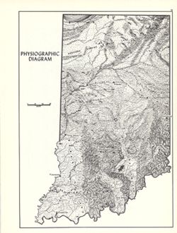
- Relief shown by landform drawing. Shows southern limit of glaciation in Indiana. Originally compiled approximately 1932 by J.E. Switzer, Department of Geology and Geography, Indiana University. Detached from: An atlas of Indiana / by Robert C. Kingsbury , with contributions from John M. Hollingsworth and others. Bloomington, Indiana : Department of Geography, Indiana University, [1970]. Page 15.
- Call Number
- G4091.C21 1970 .S96
- Caption
- Imprint: Bloomington, Indiana : Department of Geography, Indiana University, [1970]
- Filename
- VAC3073-M-00819
- Subject
- Geographic Subject: Indiana
- Topical Subject: Physiographic provinces
- Topical Subject: Physical geography
- Title
- Physiographic diagram
- Producer
- Switzer, J. E. (Jesse Elmer)
- Kingsbury, Robert C.
- Physical Description
- Dimensions: 26 x 18 cm, on sheet 28 x 21 cm
- Scale: Approximately 1:1,850,000
- Item Identifiers
- Alternate ID: 317383IP
- Title Control Number: a15938799
- Persistent Identifier
- Holding Location
- Bloomington - Herman B Wells Library
1320 E 10th St.
Bloomington, IN 47405
Contact at libref@iu.edu, (812) 855-0100
- Bloomington - Herman B Wells Library
- Campus
- IU Bloomington
- Date Created
- 1970
- Provenance
- An atlas of Indiana / by Robert C. Kingsbury [1970].
- Publisher
- Indiana University. Department of Geography
Relationships
Relationships
- In Collection:
Items
Show Item Images
| Thumbnail | Title | Date Uploaded | Visibility | Actions |
|---|---|---|---|---|
|
VAC3073-M-00819.jp2 | 2023-09-27 | Public |
|