
Image
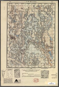
P-36-102-A Чимойла Public Deposited
- Original Publication Date
1933
- Genre
- Topographic Maps
- Military Maps
- Location
- Coordinates: 61.167, 32.5, 61.333, 32.75
- Related URL
- Abstract
- Modern area represented: Chimoyla, Republic of Karelia, Russia
- Call Number
- GM G7000 s50 .S68 sheet P-36-102-A
- City
- Чимойла (Chimoyla)
- Copyright Owner
- No Copyright - United States
- Country
- СССР (USSR)
- Filename
- VAC9619-002925
- Subject
- Topical Subject: Maps
- Geographic Subject: Chimoyla
- Topical Subject: Soviet Union
- State/Region
- Карельская АССР (Karelian Autonomous Soviet Socialist Republic)
- Title
- P-36-102-A Чимойла
- Physical Description
- Scale: 1:50,000
- Language
- Russian
- Persistent Identifier
- Campus
- IU Bloomington
- Provenance
- DMA Topographic Center, Army Map Service Library, Library of Congress Geography & Map Division
Relationships
Relationships
- In Collection:
Items
Show Item Images
| Thumbnail | Title | Date Uploaded | Visibility | Actions |
|---|---|---|---|---|
|
VAC9619-002925.jp2 | 2024-01-23 | Public |
|
|
VAC9619-U-003075.jp2 | 2024-01-23 | Public |
|