
Image
1962 state highway system of Indiana Public Deposited
- Genre
- Road maps
- Location
- Coordinates: W0880500 W0844700 N0414500 N0374600
- Related URL
- Abstract
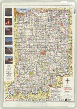
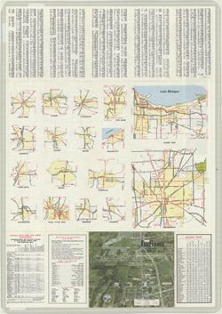
- Panel title: 1962 Indiana official highway map. Relief shown by spot heights. Includes index, distance table, color illustrations, and text. Index, distance table, indexed table of state park and forest information, directory of state police posts, color illustrations, and 18 local route maps on verso.
- Call Number
- G1403 .S7 1962
- Caption
- Imprint: [Indianapolis] : State Highway Commission, [1962]
- Filename
- VAC3073-M-01224
- Subject
- Geographic Subject: Indiana
- Topical Subject: Roads
- Title
- 1962 state highway system of Indiana
- Producer
- Indiana. State Highway Commission (1961-1981)
- Physical Description
- Scale: Approximately 1:633,600
- Dimensions: 94 x 59 cm
- Item Identifiers
- Title Control Number: a18406041
- Persistent Identifier
- Holding Location
- Bloomington - Herman B Wells Library
1320 E 10th St.
Bloomington, IN 47405
Contact at libref@iu.edu, (812) 855-0100
- Bloomington - Herman B Wells Library
- Campus
- IU Bloomington
- Date Created
- 1962
- Provenance
- Indiana state highway system
- Publisher
- Indiana. State Highway Commission (1961-1981)
Relationships
Relationships
- In Collection:
Items
Show Item Images
| Thumbnail | Title | Date Uploaded | Visibility | Actions |
|---|---|---|---|---|
|
VAC3073-M-01224.jp2 | 2023-09-27 | Public |
|
|
VAC3073-00578.jp2 | 2023-09-27 | Public |
|