
Image
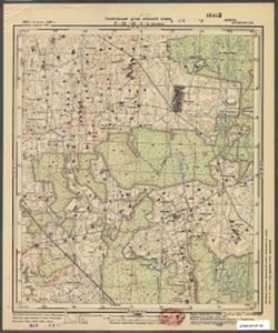
N-34-36-A-г Ругяны Public Deposited
- Genre
- Topographic Maps
- Military Maps
- Location
- Coordinates: 55.1667, 23.625, 55.25, 23.75
- Related URL
- Abstract
- Modern area represented: Rugėnai, Lithuania
- Call Number
- G7063.K2 s25 .S6 sheet N-34-36-A-d
- Caption
- Секретно
- City
- Ругяны (Rugyany)
- Copyright Owner
- No Copyright - United States
- Country
- СССР (USSR)
- Filename
- VAC9619-003626
- Subject
- Topical Subject: Soviet Union
- Topical Subject: Maps
- Geographic Subject: Rugėnai
- State/Region
- Литовская ССР (Lithuanian Soviet Socialist Republic)
- Title
- N-34-36-A-г Ругяны
- Physical Description
- Scale: 1:25,000
- Language
- Russian
- Persistent Identifier
- Campus
- IU Bloomington
- Date Created
- 1940
- Provenance
- Army Map Service Library, OMAHA, Library of Congress Geography & Map Division
- Publisher
- Генеральный штаб Красной Армии
Relationships
Relationships
- In Collection:
Items
Show Item Images
| Thumbnail | Title | Date Uploaded | Visibility | Actions |
|---|---|---|---|---|
|
VAC9619-003626.jp2 | 2024-02-09 | Public |
|
|
VAC9619-U-003915.jp2 | 2024-02-09 | Public |
|