
Image
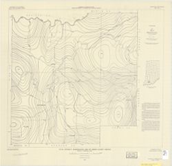
Total intensity aeromagnetic map of DuBois County, Indiana relative to arbitrary datum Public Deposited
- Genre
- Geological maps
- Thematic maps
- Location
- Coordinates: W0870423 W0864044 N0383135 N0381210
- Related URL
- Abstract
- Includes text and location map.
- Call Number
- G4093.D8C93 1950 .H46
- Caption
- Imprint: [Washington, D.C.] : U.S. Geological Survey, 1950.
- Filename
- VAC3073-M-00835
- Subject
- Topical Subject: Geomagnetism
- Geographic Subject: Dubois County (Ind.)
- Title
- Total intensity aeromagnetic map of DuBois County, Indiana relative to arbitrary datum
- Producer
- Henderson, John R.
- Physical Description
- Scale: 1:63,360
- Dimensions: 57 x 64 cm
- Item Identifiers
- Title Control Number: a8174197
- Persistent Identifier
- Campus
- IU Bloomington
- Date Created
- 1950
- Publisher
- Geological Survey (U.S.)
Relationships
Relationships
- In Collection:
Items
Show Item Images
| Thumbnail | Title | Date Uploaded | Visibility | Actions |
|---|---|---|---|---|
|
VAC3073-M-00835.jp2 | 2023-09-27 | Public |
|