
Image
Indiana transportation map 1995-1996 Public Deposited
- Genre
- Road maps
- Location
- Coordinates: W0880500 W0844700 N0414500 N0374600
- Related URL
- Abstract
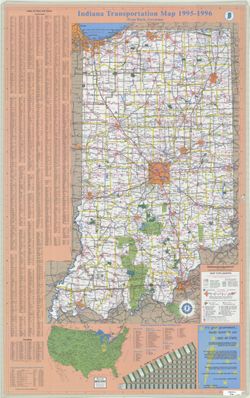
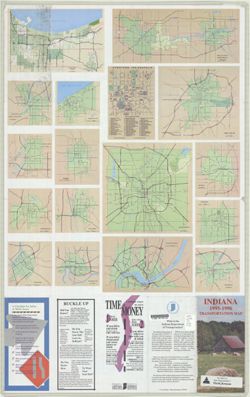
- Panel title: Indiana 1995-1996 transportation map. Includes indexes, text, color illustrations, distance table, "Map of the United States showing mileage from Indianapolis to other points," lists of "Indiana state police location and phones," and recreation areas. Text and color illustrations on verso. Ancillary maps on verso: Calumet area -- Lafayette, West Lafayette -- Michigan City -- Terre Haute -- Kokomo -- Bloomington -- Columbus -- Vincennes -- Evansville -- South Bend, Mishawaka, Elkhart -- Downtown Indianapolis -- Fort Wayne -- Indianapolis -- Muncie -- Anderson -- Falls City area -- Richmond.
- Call Number
- G1403 .S7 1995-1996
- Caption
- Imprint: [Indiana] : Indiana Department of Transportation, 1995.
- Filename
- VAC3073-M-01225
- Subject
- Topical Subject: Roads
- Geographic Subject: Indiana
- Title
- Indiana transportation map 1995-1996
- Producer
- Indiana. Department of Transportation. Graphic Engineering Division
- Physical Description
- Scale: Approximately 1:633,600
- Dimensions: 94 x 59 cm
- Item Identifiers
- Title Control Number: a18406154
- Persistent Identifier
- Holding Location
- Bloomington - Herman B Wells Library
1320 E 10th St.
Bloomington, IN 47405
Contact at libref@iu.edu, (812) 855-0100
- Bloomington - Herman B Wells Library
- Campus
- IU Bloomington
- Date Created
- 1995
- Provenance
- Indiana state highway system
- Publisher
- Indiana. Department of Transportation
Relationships
Relationships
- In Collection:
Items
Show Item Images
| Thumbnail | Title | Date Uploaded | Visibility | Actions |
|---|---|---|---|---|
|
VAC3073-M-01225.jp2 | 2023-09-27 | Public |
|
|
VAC3073-00579.jp2 | 2023-09-27 | Public |
|