
Image
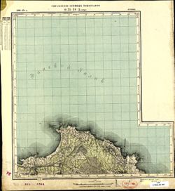
O-35-18-А Кунда Public Deposited
- Original Publication Date
1896
- Genre
- Topographic Maps
- Military Maps
- Location
- Coordinates: 59.5, 26.5, 59.667, 26.75
- Related URL
- Abstract
- Modern area represented: Kunda, Viru-Nigula Parish, Estonia
- Call Number
- G7000 s50 .S68 sheet O-35-18-A
- City
- Кунда (Kunda)
- Copyright Owner
- No Copyright - United States
- Country
- Эстония (Estonia)
- Filename
- VAC9619-001781
- Subject
- Geographic Subject: Kunda
- Topical Subject: Maps
- Topical Subject: Soviet Union
- Title
- O-35-18-А Кунда
- Physical Description
- Scale: 1:50,000
- Language
- Russian
- Persistent Identifier
- Holding Location
- Bloomington - Herman B Wells Library
1320 E 10th St.
Bloomington, IN 47405
Contact at libref@iu.edu, (812) 855-0100
- Bloomington - Herman B Wells Library
- Campus
- IU Bloomington
- Date Created
- 1897
- Provenance
- Army Map Service Library, Library of Congress Geography & Map Division, OMAHA
- Publisher
- Управление военных топографов
Relationships
Relationships
- In Collection:
Items
Show Item Images
| Thumbnail | Title | Date Uploaded | Visibility | Actions |
|---|---|---|---|---|
|
VAC9619-001781.jp2 | 2024-01-08 | Public |
|
|
VAC9619-U-000024.jp2 | 2024-01-08 | Public |
|