
Image
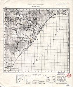
L-54-26 Самарга Public Deposited
- Original Publication Date
1936
- Genre
- Topographic Maps
- Military Maps
- Location
- Coordinates: 47, 138.5, 47.333, 139
- Related URL
- Abstract
- Modern area represented: Samarga, Primorskiy kray, Russia
- Call Number
- G7000 s100 .S7 sheet L-54-26
- Caption
- Не подлежит оглашению
- City
- Самарга (Samarga)
- Copyright Owner
- No Copyright - United States
- Country
- СССР (USSR)
- Filename
- VAC9619-002593
- Subject
- Geographic Subject: Samarga
- Topical Subject: Soviet Union
- Topical Subject: Maps
- State/Region
- РСФСР (RSFSR)
- Дальневосточный край (Far Eastern kray)
- Title
- L-54-26 Самарга
- Physical Description
- Scale: 1:100,000
- Language
- Russian
- Persistent Identifier
- Campus
- IU Bloomington
- Provenance
- DMA Topographic Center, Library of Congress G & M Division, Army Map Service Library, OMAHA
- Publisher
- Управление военных топографов РККА
Relationships
Relationships
- In Collection:
Items
Show Item Images
| Thumbnail | Title | Date Uploaded | Visibility | Actions |
|---|---|---|---|---|
|
VAC9619-002593.jp2 | 2024-01-18 | Public |
|
|
VAC9619-U-002275.jp2 | 2024-01-18 | Public |
|