
Image
1991-92 Indiana state highway system Public Deposited
- Genre
- Road maps
- Location
- Coordinates: W0880500 W0844700 N0414500 N0374600
- Related URL
- Abstract
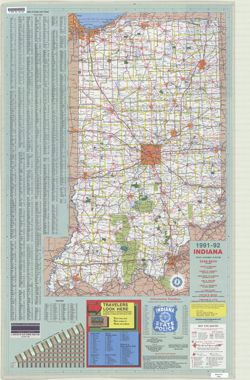
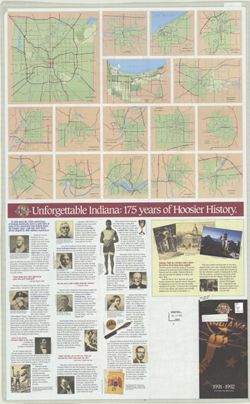
- Panel title: Indiana, 1991-1992. Includes indexes, list of points of interest, mileage chart, and directories. Text, illustrations (some color), and 16 local route maps on verso.
- Call Number
- G1403 .S7 1991-1992
- Caption
- Imprint: [Indianapolis] : [Indiana Department of Transportation], [1991]
- Filename
- VAC3073-M-01216
- Subject
- Topical Subject: Roads
- Geographic Subject: Indiana
- Title
- 1991-92 Indiana state highway system
- Producer
- Indiana. Department of Transportation. Division of Engineering Services
- Physical Description
- Scale: Approximately 1:633,600
- Dimensions: 94 x 59 cm
- Item Identifiers
- Title Control Number: a18406103
- Persistent Identifier
- Holding Location
- Bloomington - Herman B Wells Library
1320 E 10th St.
Bloomington, IN 47405
Contact at libref@iu.edu, (812) 855-0100
- Bloomington - Herman B Wells Library
- Campus
- IU Bloomington
- Date Created
- 1991
- Provenance
- Indiana state highway system
- Publisher
- Indiana. Department of Transportation
Relationships
Relationships
- In Collection:
Items
Show Item Images
| Thumbnail | Title | Date Uploaded | Visibility | Actions |
|---|---|---|---|---|
|
VAC3073-M-01216.jp2 | 2023-09-27 | Public |
|
|
VAC3073-00570.jp2 | 2023-09-27 | Public |
|